
Basin and Range Province - Teritiary ExtensionGeneral geology of the Basin and Range ProvinceMechanisms of Basin and Range faultingIdaho Basin and Range south of the Snake River PlainIdaho Basin and Range north of the Snake River PlainLocal areas of active and recent Basin & Range faulting: Borah Peak
|
Vocabulary Words
|
 PDF Slideshows:
General geology of the Basin and Range Province
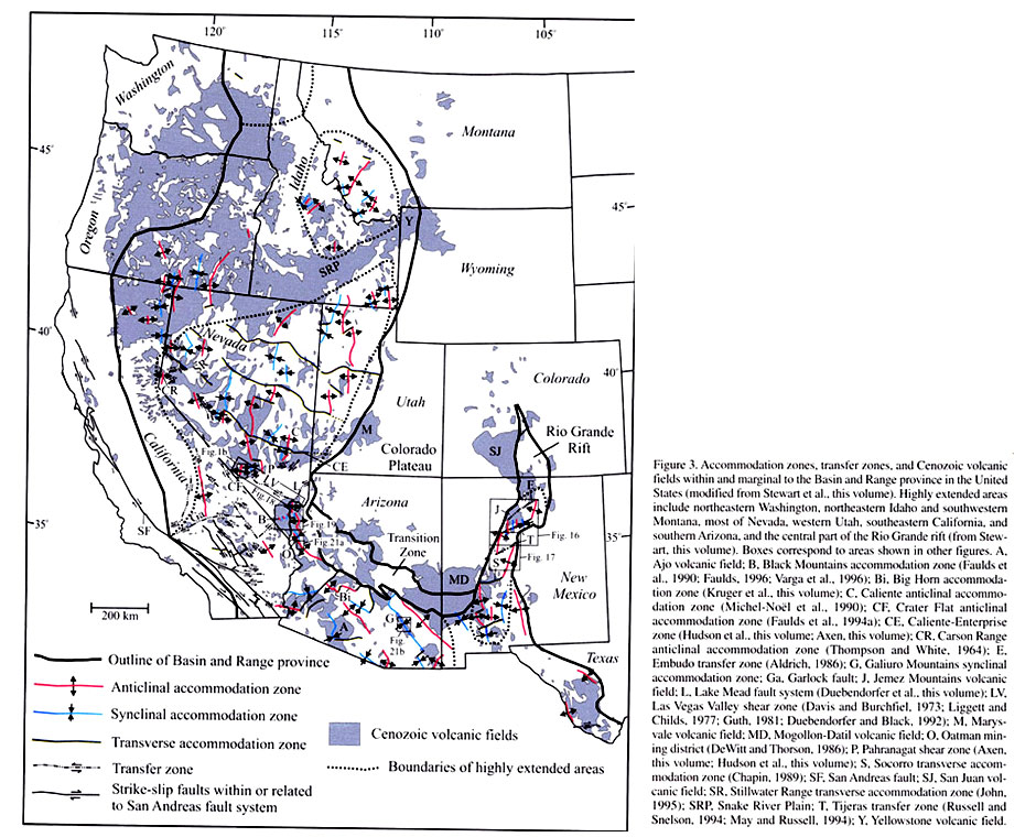
The Basin and Range Province generally includes most of eastern California, eastern Oregon, eastern Washington, Nevada, western Utah, southern and western Arizona, and southeastern Idaho.
The Basin and Range Province is characterized by extension, ranging from a total of 50% or less to 200% extension of the pre-Basin and Range land area (Faulds and Varga, 1998). This extension occurs mostly along large normal faults and fault zones where these normal faults interact with each other. The map shows the entire Basin and Range Province, including accommodation zones, transfer zones and volcanism associatied with extension.
Accomodation and transfer zones are zones where individual extended areas are overlapped or juxtaposed, respectively. These will be explored further in the "Mechanisms" section.
Map from Faulds and Varga, 1998. Click on figure for enlarged image.
Basin and Range extension began during the Miocene Epoch (~17 Ma) near the Northern Nevada Rift in the center of the province and has continued through present, propogating westward toward the Sierra Nevada and eastward into southeastern Idaho and westernmost Wyoming. Extension is a result of the cessation of the compression during the Cordilleran Orogeny. During the Cordilleran Orogeny, there was great crustal thickening, and the Basin and Range counteracts that thickening by crustal thinning through extension. The Basin and Range Province in Idaho is cross-cut by the volcanic track of the Snake River Plain. The map below shows the extent of the Basin and Range Province in southeastern Idaho.

Figure redrawn from Kuntz et al., 1992, Fig. 1
The Basin and Range Province is characterized by a series of northeast-southwest trending mountain ranges, which have been uplifted along normal faults and associated fault zones. These fault zones can be quite complicated and will be discussed in greater detail in the next section.
Mechanisms of Basin and Range Faulting
The oldest basin and range faulting occurred in the central part of the province and has migrated eastward and westward, hence the youngest, most active faults are located in southeastern Idaho and western Wyoming, and along the eastern front of the Sierra Nevada. The normal faults of the Basin and Range Province are driven by extensional forces, which mimic larger scale plate dynamics. Prior to Basin and Range extension, the Pacific Plate was subducting underneath the North American Plate in a compressional regime. This period of subduction included about 200 million years worth of orthogonal compression. In Eocene time, plate interactions changed from orthogonal compression to oblique strike-slip (transform) along the San Andreas Fault system in California. Once the compressional forces ceased, the stressed continental crust of the North American Plate was able to relax, isostatic rebound began to take place, and hence extensional forces dominated. Extension from relaxation is generally in an east-west direction. Extension due to plate interaction between the Pacific and North American is in a northwest-southeast direction. The Basin and Range faults are oriented northeast-southwest, in response to both of these directed extensions. Due to these extensional forces, the metamorphic core complex detachment faults developed, exposing the center of the core complexes. To review metamorphic core complexes, refer back to Module 1.
The Basin and Range Province contains a mixture of fault dynamics. The most classic fault geometry contains groups of en echelon listric normal faults, which flatten at depth. Where motion is transferred from one fault to another, a transfer zones or accommodation zone is present.
The figure shows the difference between these two zones. Transfer zones are boundaries between two extensional (normal faulted) areas, and accommodation zones are areas of overlap. In the transfer zones, a strike-slip component of faulting develops to balance the forces of each fault area on each side of the transfer zone. In an accommodation zone, buckling of the land occurs (either anticlinal or synclinal) to balance the forces in both of the faulted areas within the overlapped zone.
Figure shows transfer zone (A) and accomodation zone (B) -from Faulds and Varga, 1998.
Idaho Basin and Range south of the Snake River Plain

This map and cross section shows faulting throughout southern Idaho, south of the Snake River Plain. Most valleys in southern Idaho are formed by typical Basin and Range faulting.
The cross section below is from Rocks, Rails, and Trails, and follows cross section line A-A', on the map of SE Idaho. Note the horst and graben topography, typical of the Basin and Range Province. Also of great significance in this cross section is the Albion Range Core Complex, which was unroofed along the Raft River detachment, during ductile Basin and Range extension. Note also that most of the grabens are filled in by syntectonic Quaternary alluvium.
For a closer look of the Basin and Range in southeast Idaho, let's focus on a few specific examples.
Below is the map of Bonneville County, from the Digital Atlas of Idaho, located in the eastern edge of the Basin and Range Province.
Click here for the map with explanations, from the Digital Atlas of Idaho web site. Take a look at the eastern and southeastern areas of the Bonneville County map.
There are 2 major normal faults trending northwest in the blue-color-coded Paleozoic units, the Snake River fault and the Grand Valley fault. These faults dip toward each other and form an accomodation zone. In the southwestern corner of the east side of the map, there is another normal fault, barely in view, which trends the same direction as the previous 2 faults. The folding which occurs between these two areas of normal faulting is caused by the accommodation zone between these two areas of normal faulting.

Another area which exemplifies classic Basin and Range faulting is shown in the map below, a joined geologic map of Bannock and Franklin Counties, from the Digital Atlas of Idaho website. Click on the highlighted word-link for the map with explanations of Bannock County and Franklin County. You can see normal faults which trend northwest, about the same orientation of the combined counties. The main faults dip toward each other, bounding both sides of the Portneuf Valley in Bannock County and Cache Valley in Franklin County. The valleys in between these major normal fault systems are considered accommodation zones.

Idaho Basin and Range North of the Snake River Plain
The cross section below, north of the Snake River Plain, shows the typical horst and graben topography of the Basin and Range Province (from Rocks, Rails, and Trails). This cross section does incorporate more widespread intrusive igneous activity, such as the Idaho Batholith, which is not part of the Basin and Range (see Module 5), and the Beaverhead Pluton, which is much older and is faulted and exposed by the Beaverhead normal fault.

A map view of Custer County, a typical Basin and Range faulted area in central Idaho, is shown below. This map is from the Digital Atlas of Idaho; click here for the map with explanations from the Digital Atlas of Idaho website. As you can see all throughout this county, there are northwest trending Basin and Range-type normal faults.
 The best-defined faulted area is along the eastern side of Custer County, where at least three major normal faults all dip to the southwest. The minor nearby faults which mimic these larger ones, are part of the accommodation zone, where pressure from the main system is dispersed. The folds in the Lost River Range, which trend in the same direction as the fault system, are older than the Basin and Range faulting, having formed during the Cretaceous compressional deformation of the Sevier Orogeny.
On a larger scale, the map below shows a general paleogeographic map of southern Idaho in the recent geologic past (9-3.2 Ma, Lake Idaho time). Where the two discontinuous sub-lakes of Lake Idaho are shown, Glenns Ferry lake and Chalk Hills Lake, there are two large Basin and Range-type normal faults bounding the western Snake River Plain.
The lakes are formed in the graben between these two faults. You will also notice that between these faults is a anticlinal fold, which is the accommodation zone between these faults.

Figure from Link et al., 2002.
Local areas of active and recent Basin and Range faulting: Borah Peak Earthquake
The largest earthquake to be recorded in Idaho was the Borah Peak earthquake on October 28, 1983. It was a magnitude 7.3, the largest in the lower 48 states since the 1959 Hebgen Lake earthquake in Montana (magnitide 7.5). The Borah Peak earthquake was located on the Lost River fault, along the east side of the Lost River range. The towns of Mackay and Challis suffered extensive damage, with total damage costs estimated at $12.5 Million. 2 deaths occurred in Challis from debris of falling buildings.
Please visit the following links for maps and further information regarding the Borah Peak earthquake:
Idaho Geologic Survey, Borah Peak earthquake Fact Sheet.
Historical Earthquakes in Idaho, 1880-1989.
USGS, Information by Region Seismic Hazard Map.
Additional Reading
Digital Atlas of Idaho: Earthquakes in Idaho.
Rocks, Rails, and Trails, Chapter 2 (Link and Phoenix, 1996).
References
Faulds, J. E., and Varga, R. J., 1998, The role of accomodation zones and transfer zones in the regional segmentation of extended terranes, in Fauds, J. E., and Stewart, J. H., eds., Accomodation Zones and Transfer Zones: The Regional Segmentation of the Basin and Range Province, Geological Society of America, Special Paper 323, p. 1-45
Kuntz, M.A., Covingyton, H.R., and Schorr, L.J., 1992, An overview of basaltic volcanism of the eastern Snake River Plain, Idaho: in Link, P.K., Kuntz, M.A., and Platt, L.B., eds, Regional geology of eastern Idaho and western Wyoming: Geological Society of America Memoir 179, p. 227-267.
Link, P. K., and Janeke, S. U., 1999, Geology of East-Central Idaho: Geologic Roadlogs for the Big and Little Lost River, Lemhi, and Salmon River Valleys, in Hughes, S. S., and Thackray, G. D., eds., Guidebook to the Geology of Eastern Idaho: Idaho Museum of Natural History, p. 295-334
Link, P.K., and Phoenix, E.C., 1996, Rocks, Rail, & Trails, 2nd Edition, Idaho Museum of Natural History, Pocatello, ID, 193 p.
Link, P. K., McDonald, H. G., Fanning, C. M., and Godfrey, A. E., 2002, Detrital Zircon Evidence for Pleistocene Drainage Reversal at Hagerman Fossil Beds National Monument, Central Snake River Plain, Idaho, in Bonnichson, B., White, C. M., and McCurry, M., eds., Tectonic and Magmatic Evolution of the Snake River Plain Volcanic Province: Idaho Geological Survey Press, Bulletin 30, p. 105-119
Orr, W. N. and Orr, E. L., 2002, Geology of the Pacific Northwest, Second Edition: McGraw-Hill Higher Education, New York , NY , 337 p.
---------------------------
Continue to Module 10 - Columbia River Basalts