
|
Vocabulary Words |

Accreted Terranes in Western Idaho
Through much of Phanerozoic time, subduction of Pacific Ocean plates beneath North America has resulted in the accretion of crustal fragments to the western margin of the continent. A broad swath of the present continental margin is underlain by rocks of these accreted terranes that have diverse origins as Paleozoic-Mesozoic crustal fragments from the ancestral Pacific. The western side of Idaho preserves some of these tectonic fragments, the Blue Mountains terranes, and the collision zone along which they were sutured to the North American continent in late Mesozoic time.
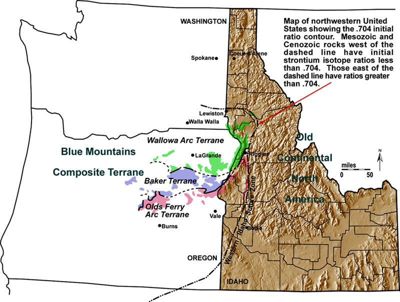
Map showing areas in western Idaho underlain by accreted terranes that extend into Washington and Oregon.
Following suturing, deformation and intrusion continued in what is now western and central Idaho as subduction was re-established. East of the suture zone, intrusion of the Late Cretaceous-Paleocene Idaho batholith ensued, followed by the Eocene Challis magmatic event. Most of the suture zone and accreted terranes in Idaho were subsequently covered by voluminous Columbia River basalt flows during Miocene time. Exposures of these features are now preserved in spectacular canyons, including Hell's Canyon, that were cut during Pliocene to Recent time.
Three major terranes comprise the Blue Mountains composite terrane in Idaho. These are Permian to Triassic fragments of oceanic island arcs, continental fringing arcs, and various subduction-related mélange that were amalgamated, and underwent Late Triassic metamorphism and Triassic-Jurassic sedimentation, before collision with the North American margin. From north to south, these terranes are the Wallowa, Baker, and Olds Ferry terranes.
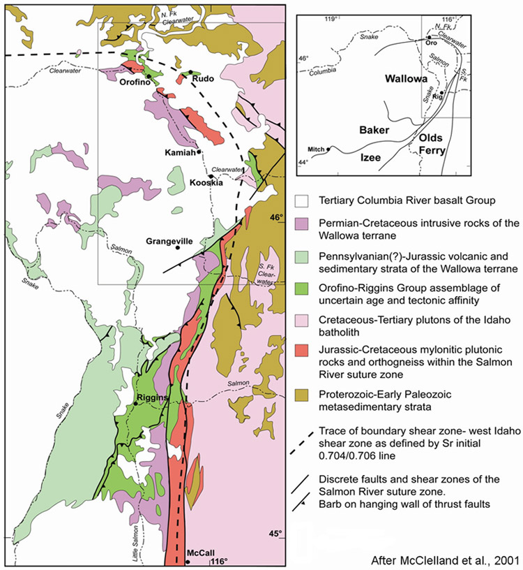
Map showing composite Blue Mountains terrane and geology of the suture zone and adjacent North American terranes.
Most of the Wallowa Terrane preserves the plutonic-volcanic arc axis of one or more island arcs and their overlying sedimentary carapace. Rock assemblages include Pennsylvanian(?)-Permian gneissic arc basement that is unconformably overlain by volcanic and volcaniclastic schists and greenstones of the Early Permian and Middle to Late Triassic Seven Devils Group (Vallier, 1977). Lying unconformably above these strata are a carbonate and sandstone-mudstone flysch package of Late Triassic-Early Jurassic age and a Middle and Upper Jurassic conglomerate, sandstone, shale, tuff and turbidite sequence. Intrusive rocks range in age from Permian to Early Cretaceous (Vallier, 1995).
The Baker Terrane is interpreted to preserve fore-arc to arc regions of the island-arc complex that were stitched to the adjacent terranes by perhaps 225 Ma. Rock assemblages include mostly mélange and blocks of island-arc crust of Devonian to Late Triassic age consisting of igneous and sedimentary rocks that have mostly been metamorphosed to greenschist grade. (Dickinson and Thayer 1978; Mullen, 1985).
The Olds Ferry terrane contains similar lithologies to the Wallowa terrane, and appears to preserve parts of an arc system that was fringing the North American margin in Late Triassic time. Intrusive rocks range from middle Triassic to Cretaceous in age (Vallier, 1995).
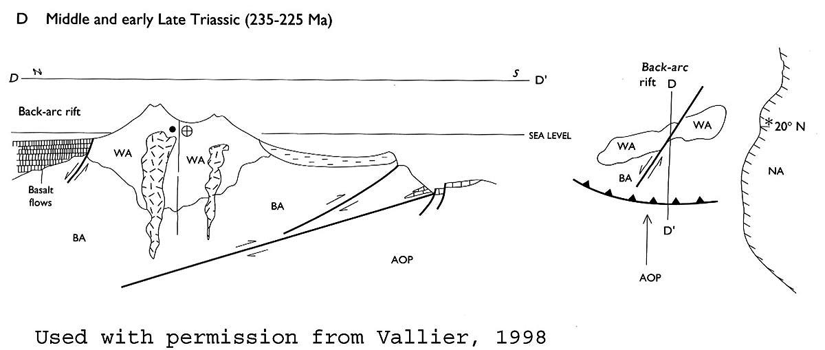
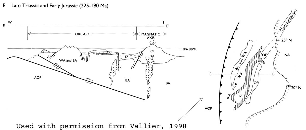


Time sequence cross sections (from Vallier, T., 1998, Islands and Rapids: A geologic story of Hells Canyon, Confluence Press, Lewiston, ID, 151 p.).

The Wallowa Terrane in Hell's Canyon
Structurally lowest levels in the Wallowa Terrane consist of mostly intrusive arc basement that in many places is metamorphosed to gneiss. Lying unconformably above, and commonly in intrusive contact with, rocks of these basement intrusive complexes are Permian-Triassic, mostly volcanic and volcaniclastic sequences of the Seven Devils Group (Windy Ridge, Hunsaker Creek, Wild Sheep, and Doyle Creek Formations), which represent active island arc volcanism during oceanic subduction in the paleoPacific Ocean.
General stratigraphy of Wallowa terrane. From Vallier (1998).
Arc volcanism largely ceased by early Late Triassic time (Carnian Stage). A depositional hiatus ensued, followed by the formation of Late Triassic to Early Jurassic limestone platforms of the Martin Bridge Formation and associated calcareous turbidite deposits of the coeval, to potentially slightly younger, Hurwal Formation. A period of pronounced deformation, uplift and erosion then occurred, followed by deposition of Middle- to Late Jurassic shale/siltstone turbidite sequences and channel conglomerates of the Coon Hollow Formation. Regional orogenesis occurred in the Late Jurassic and Early Cretaceous, which included intrusion of quartz diorite, diorite, and gabbro plutons and andesite dikes, folding, faulting and cleavage formation, and uplift and exhumation.
Basement intrusive complexes
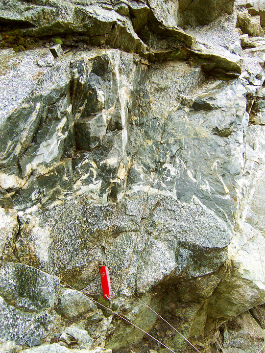 |
Outcrop of gneissic gabbro, and diorite in the Cougar Creek intrusive complex, Upper Pittsburg Landing. Pocket knife is 8 cm. Basement intrusive complexes consist of orthogneiss of silicic to mafic igneous origin, gabbro, diorite, quartz diorite, tonalite, and granitic intrusives, and andesite and basalt dikes. Ages of gneissic units are some of the oldest in the Wallowa Terrane and include Permian, and possibly Pennsylvanian U/Pb zircon dates (Walker, 1986). |

Outcrop of mylonite granite in the Cougar Creek intrusive complex, Upper Pittsburg Landing. Pocket knife is 8 cm. |
|
These complexes are in nonconformable, intrusive, and faulted contact with overlying volcanic sequences of the Seven Devils Group. They represent the deeper roots of the Wallowas island arc magmatic system and many probably fed lavas erupting at the surface. |
||

Permian Rocks
Permian pyroclastic breccia and tuffs with rare lava flows comprise the Windy Ridge Formation. Most of this volcanic material is silicic in composition. Potassium-poor rhyolite tuff containing quartz phenocrysts with a distinctive blue tint is common. These rocks in part interfinger with sequences in the Hunsaker Creek Formation, indicating similarity in age (Vallier, 1977).
The Early Permian Hunsaker Creek Formation consists of a widely diverse sequence of rocks that include pyroclastic breccia and tuffs, conglomerate, sandstone, and siltstone, and relatively rare basalt, andesite, and low-Potassium rhyolite lava flows. Age control is from fossil assemblages that include brachiopods and bivalves (Vallier, 1977).
Triassic Wild Sheep Creek Formation
The Triassic Wild Sheep Creek Formation rests unconformably on Permian strata and consists of greenschist metamorphosed, dominantly green colored volcaniclastic, volcanic, and epiclastic rocks and limestone (metamorphosed to marble in places). Recognizable protoliths include plagioclase-hornblende porphyritic volcanic flow and intrusive rocks (mostly sills), volcanic breccias, and epiclastic conglomerate, greywacke and arkose, siltstone, and argillite. Epiclastic rocks contain common feldspar crystals in addition to volcanic lithic fragments. Volcanic compositions range from basalt to andesite. Pillow basalt lavas are common. Considered latest Middle to early Late Triassic in age based on fossil assemblages (Vallier, 1977).

Fig. 1-View to northeast of shallowly north-dipping sequences in the Wild Sheep Creek Fm. in Hell's Canyon near confluence with Salmon River . Lower, well-bedded outcrops represent mostly sedimentary and volcaniclastic sequences; more massively bedded outcrops above are mostly volcanic.
Fig. 2-Outcrop of volcaniclastic unit in Wild Sheep Creek Fm. Knife is 8 cm.
Fig. 3-River-polished outcrop of thinly-bedded epiclastic siltstone-sandtone sequence in Wild Sheep Creek Fm. Hammer is 30 cm.
Triassic Doyle Cr. Fm
 View to northeast of steeply northwest-dipping sequences in the Doyle Creek Fm. in Hell's Canyon near confluence with Grande Ronde River. View to northeast of steeply northwest-dipping sequences in the Doyle Creek Fm. in Hell's Canyon near confluence with Grande Ronde River. |
Rocks of the Doyle Creek Formation are mostly greenschist metamorphosed, dominantly red colored, thin to medium bedded, mostly epiclastic rocks comprising arkosic pebble conglomerate and sandstone, greywacke, siltstone, and argillite. Mud rip-up clasts are very common. Volcanic flows, volcanic breccias, and dikes and sills are less common. The base of this unit is poorly defined and appears gradational with rocks of the underlying Wild Sheep Creek Formation. Vallier (1977) considers this unit in part a subaerial equivalent to the mostly submarine rocks of the Wild Sheep Creek Formation. The inferred Late Triassic age has been determined by fossil assemblages in bounding formations (Vallier, 1977). |
 Outcrop of massively-bedded volcaniclastics with characteristic red color in Doyle Creek Fm. Hammer is 30 cm.
 |
Triassic Martin Bridge and Triassic-Jurassic Hurwal Formation
The Martin Bridge Formation lies unconformably on Doyle Creek and Wild Sheep Creek Formation rocks. It consists of limestone and marble, mostly recrystallized massive sparite and micrite, with chert lenses and uncommon thinly bedded calcareous siltstone and shale. Also includes gray-green colored thinly bedded calcareous greywacke and siltstone, and argillaceous limestone. Considered to be Late Triassic (Carnian and Norian Stages) based on fossil assemblage (Vallier, 1977).
Martin Bridge rocks interfinger with those of the Triassic-Jurassic Hurwal Formation, consisting of thinly bedded, turbidite-dominated, phyllitic, fine-grained greywacke, siltstone, and shale with less common pebble conglomerate and thin limestone beds. Coarser lithologies tend to be calcareous. Common sedimentary structures include load casts and graded bedding. The Hurwal Fm. has been defined as Late Triassic to Early Jurassic in age in the Wallowa Mountains of northeastern Oregon (Follo, 1994). Many workers consider rocks of the Martin Bridge and Hurwal Formations as different lithofacies of the same sequence; they are rarely found together in the same area.
Jurassic Coon Hollow Formation
Rocks of the Coon Hollow Formation lie in angular unconformity on older Triassic and Jurassic sequences. The unit consists of thinly bedded to thickly laminated, turbidite-dominated, intercalated black shale and gray siltstone, with less common lithic sandstone and pebble conglomerate. Poorly sorted cobble conglomerate occurs in discontinuous lenses less than 1 m in thickness. Clasts, mostly chert and rarely limestone, are commonly rounded and 0.5 to 5 cm long, but locally reach 10 cm in size. Uncommon fossils include plant hash and tree bark as well as ammonites. This unit has been defined as late Middle Jurassic to early Late Jurassic in this region (Morrison, 1964; Vallier, 1977; Goldstrand, 1994).
Structural and metamorphic history
The Permian to Jurassic Wallowa Terrane rocks are variably deformed in Idaho, and most have been overprinted by sub- to lower-greenschist grade metamorphism that includes chlorite and epidote, and, in places, actinolite. Open to tight meter to 100 meter scale folds are common across the terrane. These have mostly north to northeast-plunging fold axes. Axial planar, moderately to strongly developed, spaced to penetrative cleavage that is mostly steeply dipping and northeast to north striking is also common, and is typically defined by lower greenschist grade metamorphic minerals listed above. Some of this deformation appears to have initiated following deposition of the Seven Devils Group (Triassic Doyle Creek Formation) and before deposition of Jurassic Coon Hollow Formation. However, most deformation occurred following the final stages of Coon Hollow deposition in Late Jurassic time. Jurassic-Cretaceous plutons described below mostly cross-cut folds and cleavage that resulted from this deformation, constraining this episode of deposition to latest Jurassic time.
Jurassic-Cretaceous intrusive rocks
Rocks of the Wallowa Terrane are intruded by a number of hornblende-biotite quartz diorite, hornblende diorite, and hornblende-pyroxene gabbro plutonic complexes. In some regions these plutons have completely intruded-out Wallowa volcanic and sedimentary rocks. Quartz diorite is the most common lithology and is generally medium- to coarse-grained, equigranular, and massive to foliated. Major minerals include 8-32 percent hornblende, 0-20 percent biotite, 0-5 percent epidote, 10-25 percent quartz, and 0-5 percent K-feldspar. Apatite, sphene, allanite, and rutile (in biotite) are common accessory minerals. Mutually cross-cutting relationships and mingling textures between quartz diorite, diorite, and gabbro are common suggesting that they are comagmatic units. The more mafic rocks are generally hornblende-rich, typically very heterogeneous, igneous and meta-igneous rocks, primarily diorite and gabbro. Ages from both U-Pb zircon and 40 Ar/ 39 Ar hornblende systematics indicate the Jurassic to Cretaceous age range for these units. U-Pb zircon ages generally fall in the range of 160-120 Ma (Vallier, 1995; unpublished data).
Western Idaho Suture Zone
The Salmon River suture zone represents the western boundary of North American sialic crust in western Idaho (Lund and Snee, 1988). Where originally defined, near the towns of McCall and Riggins , Idaho , the zone consists of a belt of deformation that includes a series of prominent west-vergent thrust sheets on its western side (Hamilton, 1963; Selverstone et al., 1992; Manduca et al., 1993) and variably developed east-vergent thrusts forming local flower structure on its eastern side (Lund and Snee, 1988). The inferred crustal boundary shear zone within this belt of deformation is defined by the initial Sr 0.704/0.706 isotope line that is derived from Jurassic and Cretaceous plutons (Armstrong et al., 1977; Fleck and Criss, 1985; Manduca, 1988). The boundary is steep and strikes nearly north-south from ~44oN to 46.5oN latitude. At ~46.5oN, near Orofino, the boundary shear zone abruptly strikes W-NW and continues westward, to be finally covered by Miocene basalt strata of the Columbia River Plateau province.
Along the boundary shear zone, the composite Wallowa island arc terrane was obliquely underthrust beneath the continental margin in Early Cretaceous time (Lund and Snee, 1988; Selverstone et al., 1992; Manduca et al., 1993), and since has been profoundly modified by deformation along the Salmon River suture zone. This shear zone developed in an intra-arc setting by 118 Ma, and was intruded by 118 to 90 Ma foliated, locally epidote-bearing, tonalite sheets. The final dynamothermal event included intrusion of tonalitic plutons of the Idaho batholith at 93 to 88 Ma, followed by rapid uplift (estimated at 4 mm per year), cooling, and erosion of plutons and host rocks starting at 88 Ma. Late-stage plutons of the Idaho batholith cooled below the hornblende Ar-blocking temperature between 75 and 70 Ma (Lund and Snee, 1988; Snee et al., 1995).
McClelland et al. (2000) interpreted the steeply dipping ductile fabrics and structures within part of the originally defined Salmon River suture zone as a mid- to Late Cretaceous dextral transpressional shear zone, the Western Idaho shear zone, that truncated structures formed during accretion of the composite Wallowa terrane. Thus, this boundary may have a two-staged evolution: an early, pre-118 Ma accretionary history on east-dipping thrust faults, followed by post-accretion deformation and exhumation by transpression that continued into Paleogene time. This evolution is consistent with a large body of paleomagnetic data supporting large northward displacements of outboard terranes along the Cordilleran margin during Late Cretaceous-Paleogene time (e.g. Beck, 1986; Cowan et al., 1997), and provides evidence of a fault zone that could have accommodated at least some of the necessary fault displacement. Since faults do not usually consist of a single, clean fracture, the term fault zone is used when referring to the zone of complex deformation that is associated with the fault plane.
Continental Rocks east of the Western Idaho Suture Zone
To the east and north of the Salmon River suture zone, wall rocks of the Idaho batholith include Proterozoic metasedimentary rocks of the Belt Supergroup and possible pre-Belt strata, both consisting largely of clastic and carbonate bearing sequences (now schists and gneisses) (Hietanen, 1962; Hamilton, 1963; Myers, 1982; Lewis et al., 1992), and Late Proterozoic and Paleozoic siliciclastic and carbonate rocks of the Cordilleran miogeocline (Lund, 1984; Lund et al., 2003).
Distinct rock assemblages adjacent to, and within, the Western Idaho Suture Zone
A series of poorly understood assemblages occurs immediately west of, and in tectonic slices within, the Salmon River suture zone. These include variably metamorphosed rocks with protoliths ranging from sedimentary to volcanic rocks. Age estimates for this assemblage range from Precambrian to Late Cretaceous with, as yet, no direct age constraints for sedimentary or volcanic material (e.g. Hamilton, 1963; Lund and Snee, 1988; Davidson, 1990).
References
Armstrong, R.L., Taubeneck, W.H., and Hales, P.O, 1977, Rb-Sr and K-Ar geochronometry of Mesozoic granitic rocks and their Sr isotopic composition, Oregon , Washington , and Idaho : Geological Society of America Bulletin, v. 88, p. 397-411.
Beck, Jr., M.E., 1986, Model for late Mesozoic and early Tertiary tectonics of coastal California and western Mexico and speculations on the origin of the San Andreas fault : Tectonics v. 5, p. 49-64.
Cowan, D.S., Brandon , M.T., and Garver, J.I., 1997, Geologic tests of hypotheses for large coastwise displacement—A critique illustrated by the Baja British Columbia controversy: American Journal of Science, v. 297, p. 117-173.
Davidson, G.F., 1990, Cretaceous tectonic history along the Salmon River Suture Zone near Orofino , Idaho ; metamorphic, structural, and 40Ar/39Ar thermochronologic constraints: Oregon State University , M.S. thesis, 143 p.
Dickinson, W.R., and Thayer, T.P., 1978, Paleogeographic and paleotectonic implications of Mesozoic stratigraphy and structure in the John Day Inlier of central Oregon: in Howell, D.G., and McDougall, K.A., eds., Mesozoic Paleogeography of the Western United States: Pacific Section SEPM, Pacific Coast Paleogeography Symposium 2, p. 147-161.
Fleck, R.J., and Criss, R.E., 1985, Strontium and oxygen isotopic variations in Mesozoic and Tertiary plutons of central Idaho : Contributions to Mineralogy and Petrology, v. 90, p. 291-308.
Follo, M.F., 1994, Sedimentology and stratigraphy of the Martin Bridge Limestone and Hurwal Formation (Upper Triassic to Lower Jurassic) from the Wallowa Terrane, Oregon, in T.L. Vallier and H.C. Brooks, eds., Geology of the Blue Mountains Region of Oregon, Idaho, and Washington: U.S. Geological Survey Professional Paper 1439, p. 1-27.
Goldstrand, P.M.., 1994, The Mesozoic geologic evolution of the northern Wallowa Terrane, Northeastern Oregon and Western Idaho, in T.L. Vallier and H.C. Brooks, eds., Geology of the Blue Mountains Region of Oregon, Idaho, and Washington: U.S. Geological Survey Professional Paper 1439, p. 29-53.
Hamilton , W., 1963, Metamorphism in the Riggins region, western Idaho : U.S. Geological Survey Professional Paper 436, 95 p.
Hietanen, A., 1962, Metasomatic metamorphism in western Clearwater County , Idaho : U.S. Geological Survey Professional Paper 344-A.
Lewis, R.S., Burmester, R.F., Reynolds, R.W., Bennett, E.H., Myers, P.E., and Reid, R.R., 1992, Geologic map of the Lochsa River area, northern Idaho : Idaho Geological Survey Geologic Map Series, scale 1:100,000.
Lund , Karen, 1984, Tectonic history of a continent-island arc boundary, west-central Idaho : University Park , Pennsylvania , Pennsylvania State University Ph.D. thesis, 210 p.
Lund, K., and Snee, L.W., 1988, Metamorphism, structural development, and age of the continent-island arc juncture in west-central Idaho, in Metamorphism and Crustal Evolution of the Western United States, Rubey Vol. VII , edited by W.G. Ernst, pp. 296-331, Prentice-Hall, Englewood Cliffs, N.J.
Lund, K., Aleinikoff, J.N., Evans, K.V., and Fanning, C.M., 2003, SHRIMP U-Pb geochronology of Neoproterozoic Windermere Supergroup, central Idaho: Implications for rifting of western Laurentia and synchroneity of Sturtian glacial deposits: Geological Society of America Bulletin, v. 115, p. 349–372.
Manduca, C.A., 1988, Geology and geochemistry of the oceanic arc-continent boundary in the western Idaho batholith near McCall, Ph.D. thesis, Calif. Inst. of Technology, 272 p.
Manduca , C.A. , M.A. Kuntz, and Silver, L.T., 1993, Emplacement and deformation history of the western margin of the Idaho batholith near McCall, Idaho : Influence of a major terrane boundary, Geol. Soc. Am. Bull ., 105, 749-765, 1993.
McClelland, W.C., Tikoff, B., and Manduca, C.A., 2000, Two-phase evolution of accretionary margins; examples from the North American Cordillera : Tectonophysics, v. 326, no. 1-2, p. 37-55.
Morrison, R.F., 1964, Upper Jurassic mudstone unit named in the Snake River Canyon, Oregon- Idaho boundary: Northwest Science, v. 38, p. 83-87.
Mullen, E. D., 1985, Petrologic character of Permian and Triassic greenstones from the mélange terrane of eastern Oregon and their implications for terrane origin: Geology, v. 13, p. 131-134.
Myers, P.E., 1982, Geology of the Harpster area, Idaho County , Idaho : Idaho Bureau of Mines and Geology Bulletin 25, 46 p.
Selverstone, J., Wernicke, B.P., and Aliberti, E.A., 1992, Intracontinental subduction and hinged uplift along Salmon River suture zone in west-central Idaho : Tectonics, v. 11, p. 124-144..
Snee, L.W., Lund, Karen, Sutter, J.F., Balcer, D.E., and Evans, K.V., 1995 An 40 Ar/39 Ar chronicle of the tectonic development of the Salmon River suture zone, western Idaho, in Vallier, T.L., and Brooks, H.C., eds., Geology of the Blue Mountains region of Oregon, Idaho, and Washington; petrology and tectonic evolution of pre-Tertiary rocks of the Blue Mountains region , U.S. Geological Survey Professional Paper, P 1438, p. 359-414.
Vallier, T.L., 1977, The Permian and Triassic Seven Devils Group, Western Idaho and Northeastern Washington: U.S. Geological Survey Bulletin 1437, 58 p.
Vallier, T.L., 1995, Petrology of pre-Tertiary igneous rocks in the Blue Mountains region of Oregon, Idaho, and Washington: Implications for the geologic evolution of a complex island arc , in Vallier, T.L., and Brooks, H.C., eds., Geology of the Blue Mountains region of Oregon, Idaho, and Washington; petrology and tectonic evolution of pre-Tertiary rocks of the Blue Mountains region , U.S. Geological Survey Professional Paper, P 1438, p. 125-209.
Vallier, T., 1998, Islands and Rapids: A geologic story of Hells Canyon, Confluence Press, Lewiston, ID, 151 p.
Walker, N. W. (1986), U/Pb geochronologic and petrologic studies in the Blue Mountains Terrane, northeastern Oregon and westernmost-central Idaho ; implications for pre-Tertiary tectonic evolution: Unpublished Ph.D. Dissertation, University of California, Santa Barbara , Santa Barbara , California.
![]()
Continue to Module 5 - Thrust Belt